Capturing the Estuary: New LiDAR Data Collection Underway
by Miranda Melen | Aug 28, 2025
A Milestone in Regional Data Collection
This summer marks a major milestone in regional data collection as the WRMP, in partnership with the San Francisco Bay Restoration Authority and several key agencies, launches the first comprehensive LiDAR (Light Detection and Ranging) survey of the San Francisco Bay and Delta! Collaborating with the Delta Stewardship Council, Department of Water Resources, South Bay Salt Pond Restoration Project, and Valley Water, this effort gathers high-resolution elevation data during low tide, creating the first LiDAR dataset to span the entire Estuary. LiDAR is a remote sensing technology that uses lasers from aircraft to produce precise, three-dimensional maps of the Earth’s surface. This data will enhance our understanding of our wetlands, shorelines, and restoration progress while also serving as a vital tool for shoreline planners, municipalities, and others preparing for sea-level rise.
Why We’re Collecting LiDAR
LiDAR is a powerful tool for tracking changes in wetland elevation and vegetation over time. This new dataset supports several WRMP goals, including:
- Updating the Baylands Habitat Map (BHM) 2025, which the WRMP uses to monitor changes in wetland extent, habitat types, vegetation, and other wetland characteristics.
- Establishing a baseline for future wetland restoration and shoreline resilience planning.
The WRMP coordinated this effort in collaboration with the firm NV5. To ensure the LiDAR data is as accurate as possible, we used precise ground control points. These benchmarks help us validate elevation data and improve our ability to track landscape changes over time. This marks the first iteration of Estuary-wide LiDAR data collection, which we hope will set the stage for regular updates in the years ahead.

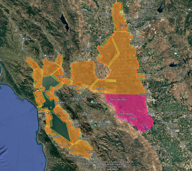
LiDAR flight plan and progress map for the San Francisco Baylands and San Joaquin Delta. Areas in pink represent completed flight lines as of August 21, while yellow lines indicate planned coverage.
Open and Accessible Data
In keeping with WRMP’s commitment to transparency and collaboration, all geospatial data collected through this effort is freely available to the public. The WRMP will produce a 2025 Digital Elevation Model (DEM) and a Digital Surface Model (DSM) – which measures the height of objects above ground – at a one-foot resolution. Once processed (early 2026), the 2025 DEM and related products will be hosted on WRMP’s data catalog, where researchers, planners, and community members can explore and download the data. For more information, visit the WRMP’s data catalog help page.
Stay in the Loop
Want to stay up to date on this and other WRMP projects? Subscribe to the WRMP Newsletter to get the latest updates, data releases, and opportunities to get involved.
