Wetlands Regional Monitoring Program
  • Monitoring Results
        • Monitoring Results
        • Data and tools for restoration and adaptation.


        • Topics

        • Baylands Geography
        • Wetlands & Sea Level Rise
        • Wetland Condition
        • Water Quality
        • Fish & Wildlife
        • Plant Communities
        • People & Wetlands
        •  


        • Metrics, Data, and Documents

        • Metrics Overview
        • Data
        • Technical Documents and Report Summaries
  • Science Framework
        • Science Framework
        • The guiding questions of the WRMP.


        • Monitoring Site Network
        • Indicator Alignment
        • Science Framework Documents
  • About
        • About the WRMP
        • How the WRMP operates.


        • History of the WRMP
        • Leadership & Governance
          • Steering Committee
          • Technical Advisory Committee
          • Workgroups
          • Staff
        • Indigenous Peoples’ Acknowledgment
        • Our Funders & Partners
        • Program Documents
        • Frequently Asked Questions
  • Engage
        • Engage with the WRMP
        • Get involved with the WRMP.


        • Recent News
        • Events
        • Newsletter
        • Volunteer Locally
        • Request Letter of Support
  • Resources
        • Resources
        • Key information to bring you up to speed and address your questions.


        • WRMP Resources

        • Technical Documents and Report Summaries
        • Data Visualizations
        • Webinars & Videos
        • External Data & Tools
        •  


        • External Resources

        • Tidal Wetlands 101
        • Other California Wetland Monitoring Programs
        • Regional Partner Organizations
Select Page
Accessing WRMP Geospatial Results Through the WRMP Landscape Profile Tool in EcoAtlas Webinar

Accessing WRMP Geospatial Results Through the WRMP Landscape Profile Tool in EcoAtlas Webinar

by Rachele Lang | Jan 16, 2026 | General, Technical, Webinars

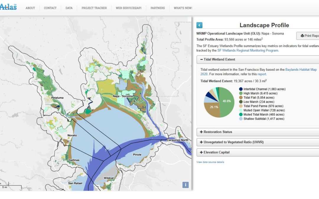
The WRMP has launched full scale data collection of tidal wetlands around San Francisco Bay to answer key management questions that will enable more successful wetland restoration and more cost-effective permit driven monitoring. The SF Estuary Wetlands Profile tool...

Recent Posts

  • KneeDeepTimes Article Highlights WRMP Lidar Survey
  • San Francisco Bay-Delta Estuary 2025 Lidar Collaboration
  • Spring 2026 Newsletter
  • Accessing WRMP Geospatial Results Through the WRMP Landscape Profile Tool in EcoAtlas Webinar
  • Winter 2025 Newsletter
Mail the team

Be in touch: [email protected]

Sign up for our Newsletter

About the Wetlands Regional Monitoring Program

About the Data Sharing Policy

Site designed by Environmental Science Associates (ESA) and developed by the San Francisco Estuary Institute and the Estuary Partnership