Wetlands Regional Monitoring Program
  • Monitoring Results
        • Monitoring Results
        • Data and tools for restoration and adaptation.


        • Topics

        • Baylands Geography
        • Wetlands & Sea-level Rise
        • Wetland Condition
        • Water Quality
        • Fish and Wildlife
        • Plant Communities
        • People & Wetlands

        • Data, Figures, and Documents

        • Metrics Overview
        • Technical Documents and Report Summaries
  • Science Framework
        • Science Framework
        • The guiding questions of the WRMP.


        • Additional Information

        • Monitoring Site Network
        • Indicator Alignment
        • Science Framework Resources
  • About
        • About the WRMP
        • How the WRMP operates.


        • History of the WRMP
        • Leadership & Governance
          • Steering Committee
          • Technical Advisory Committee
          • Workgroups
          • Staff
        • Indigenous Peoples’ Acknowledgment
        • Our Funders & Partners
        • Frequently Asked Questions
  • Engage
        • Engage with the WRMP
        • Get involved with the WRMP.


        • Recent News
        • Events
        • Newsletter
        • Volunteer Locally
        • Webinars & Videos
        • Letters of Support
  • Resources
        • WRMP Resources & Tools
        • Documents and Information


        • Tidal Wetlands 101
        • Regional Partner Organizations
        • Other California Wetland Monitoring Programs
Select Page
Introducing the Baylands Habitat Map 2020! Part 1

Introducing the Baylands Habitat Map 2020! Part 1

by Tony Hale | Oct 4, 2024 | General, Technical, Webinars

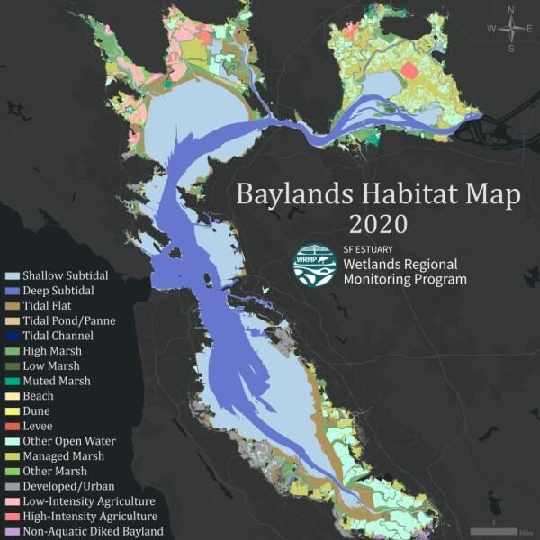
Introducing the Baylands Habitat Map 2020! Part 1 The WRMP held a webinar on October 15, 2024 to introduce the 2020 Baylands Habitat Map. Materials from the webinar are below: Notes and Q&A Slides Baylands Habitat Map factsheet Watch the Recording: About the...
Next Entries »

Recent Posts

  • Fall 2025 Newsletter
  • Wetlands, Water Quality, and PCBs in San Francisco Bay
  • Capturing the Estuary: New LiDAR Data Collection Underway
  • South Bay Salt Pond Restoration Project Lunch and Learn on the WRMP
  • Summer 2025 Newsletter
Mail the team

Be in touch: [email protected]

Sign up for our Newsletter

About the Wetlands Regional Monitoring Program

About the Data Sharing Policy

Site designed by Environmental Science Associates (ESA) and developed by the San Francisco Estuary Institute and the Estuary Partnership